1 month
€50
~1.67 EUR / day
- Corrections for all satellite systems
- Accuracy ≤ 2 cm in real time
- Technical support
- Uninterrupted 24/7 signal
GNSS correction network · Lithuania
geoRTK.LT - a professional RTK correction network for your GNSS receiver. One connection, all satellite systems and a stable, uninterrupted signal.
What is RTK
An ordinary GPS receiver in a phone or navigation device determines position to within 2-10 meters - enough for driving, but not for professional work. RTK (Real-Time Kinematic) is a technology that achieves centimeter accuracy in real time.
geoRTK.LT is a continuously operating reference network in Lithuania, broadcasting high-quality correction data for all satellite systems. Centimeter accuracy is ensured within the coverage zone, and decimeter accuracy across all of Lithuania. This is a private Lithuanian-owned project that creates value for Lithuania – generating tax revenues and directly boosting local high-tech businesses and their competitiveness.
The accuracy difference when positioning in real time.
How it works
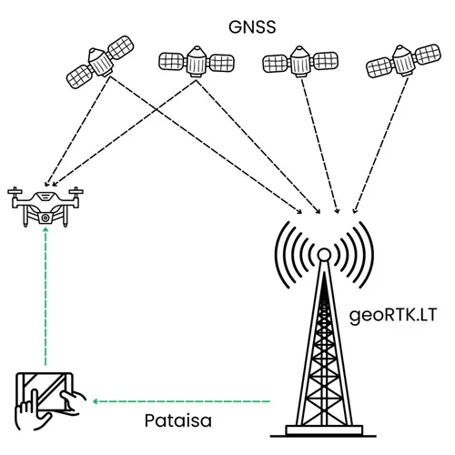
From the satellite signal to a precise position on your screen - in real time.
geoRTK.LT stations continuously receive signals from GPS, Galileo, BeiDou and Glonass satellites across Lithuania.
Base GNSS receivers compute, remove atmospheric and orbital errors, and send corrections to the network server.
Using the NTRIP 2 internet protocol, your receiver gets the corrections and fixes its position to centimeter accuracy.
Coverage
geoRTK.LT is a reference network operating continuously 24/7 in Lithuania, ensuring centimeter accuracy within the coverage zone, and decimeter accuracy across the entire territory of Lithuania.
Automatic nearest base station selection (RTK_4GNSS) or manual selection.
Plans
Every plan includes corrections for all satellite systems and technical support. Prices incl. VAT.
€50
~1.67 EUR / day
€135
~1.50 EUR / day
€365
~1.01 EUR / day
€240
~1.33 EUR / day
Orders are handled in the matuoju24.lt shop. Not sure which plan fits? Contact us - we'll advise.
geoRTK.AG · For agriculture
Plans specially tailored for agricultural seasonality and the number of machinery used - an uninterrupted 24/7 correction signal, for the selected field work period, for the precise auto-steering of tractors or combines, spraying and seeding simultaneously, with centimeter accuracy at a lower price depending on the number of machinery used in the geoRTK.LT network at one time.
Applications
One network - accuracy for every profession.
Setting out plots, topography and cadastral surveys with centimeter accuracy.
Axis setting-out, control and precise layout of buildings and roads.
Auto-steering of machinery, precise seeding and spraying without overlaps.
3D control of excavators, graders and dozers in real time.
Autonomous mapping, hydrographic surveys, environmental monitoring, rescue operations or military missions.
Feature capture and data collection with reliable coordinates.
Why geoRTK.LT
GPS, Galileo, BeiDou, Glonass all signals - more used satellites, faster and more reliable results.
The network runs around the clock so your work never stops, day or night.
The standardized NTRIP 2 protocol is compatible with most receivers - Leica, Carlson, Juniper Systems, Trimble, Topcon, Spectra, Stonex, Satlab and more.
Real people who will answer the phone and advise you - no language barrier.
Order, receive your login details and get to work - the same day.
Clear plans with no hidden fees. Longer subscription or higher number of devices – lower price.
Technical specification
Some of the world's most advanced base-station GNSS receivers (Belgium), full-spectrum GNSS antennas (Canada) and modern network management software (Germany).
Advanced technologies are implemented in geoRTK.LT base stations - AIM+ protecting against external satellite signal jamming and spoofing, IONO+ protecting against the influence of ionospheric activity, and OSNMA for Galileo authentication.
GPS (L1CA, L1PY, L2PY, L2C, L5, L1C), Galileo (L1BC, E6BC, E5a, E5b, E5), BeiDou (B1I, B2I, B3I, B1C, B2a, B2b), Glonass (L1CA, L1P, L2P, L2CA, L3).
International standard RTCM 3.x corrections broadcast via the NTRIP 2 protocol, including MSM7 messages, provide the highest resolution of phase, code, and carrier-to-noise ratio (CNR) quality.
Antenna phase-center variation < 1 mm, calibrated by GEO++ (Germany). Full Antex/AntInfo databases.
Compatible with GNSS equipment from most manufacturers - Leica, Carlson, Juniper Systems, Trimble, Topcon, Spectra, Stonex, Satlab and more.
RTK_4GNSS automatically selects the nearest base station, or you choose one manually.
FAQ
You need a GNSS receiver that supports RTK corrections over NTRIP and an internet connection (usually a SIM card in the receiver or a phone hotspot). You do not need your own base station - we provide the entire correction network.
Yes - in areas with a sufficiently open sky horizon, you will achieve ≤ 2 cm accuracy in real time. Accuracy can be affected by dense tree canopies or tall buildings, where satellite signals are obstructed or reflected. However, geoRTK.LT ensures the maximum possible accurate result even under difficult conditions.
With most modern receivers supporting the NTRIP 2 protocol and RTCM 3.x corrections - Leica, Carlson, Juniper Systems, Trimble, Topcon, Spectra, Stonex, Satlab and many others. Also with most agricultural equipment from John Deere, NovAtel, Trimble and other manufacturers.
Shortly after your order is confirmed, you will receive unique connection details generated for each device (server IP address, port, username and password). You can usually start working on the very same day.
Yes. The geoRTK.AG plan is designed for this, with an uninterrupted 24/7 signal for auto-steering of tractors and combines. Contact us regarding the number of devices you plan to use and for an individual price offer.
Contact
Not sure which plan fits your work, or need help connecting? Call or write - we'll advise and activate the service. Operated by UAB „Geodezija 3D“, weekdays 8 AM-6 PM.